Regulation of NGSO Satellite Constellations
28.03.20241. Introduction
Satellites have played a pivotal role in the connectivity ecosystem since decades. While terrestrial networks address mostly dense urban areas, satellites enable seamless communication across remote and underserved regions. Their ability to provide ubiquitous coverage ensures that even the most isolated areas remain connected, helping to bridge the digital divide. Today, Non-Geostationary Orbit (NGSO) constellations are reshaping the landscape of satellite communications and have become increasingly important for several reasons. First, they offer low-latency, high-speed internet connectivity, particularly critical for real-time applications like emergency alerts and autonomous vehicles. Second, NGSOs are democratizing access to broadband, reaching remote or rural areas where laying traditional infrastructure is challenging or costly. Third, they support the Internet of Things (IoT) and Machine-to-Machine (M2M) communications, driving advancements in various industries from agriculture to manufacturing.
Additionally, these constellations are pivotal in global scientific endeavors, including Earth observation and climate monitoring. They also play a vital role in enhancing global navigation and emergency response capabilities. Overall, NGSO constellations are one of the key enablers for achieving the United Nations Sustainable Development Goals (SDG) towards a more sustainable and globally inclusive society.
The recent growth of NGSO satellite constellations has raised new issues for policy makers and regulators to explore and tackle at various levels, including national, regional, and global. This spans a wide range of topics related to radio spectrum and Earth orbits, including policy and regulatory aspects to preserve those two scarce natural resources as well as the management of an interference-free environment for network operations, market access and emerging business models. While allowing to better respond to social priorities such as meaningful global connectivity, safety and emergency services, constellations also raise questions about space sustainability, including space traffic management, sustainable use of radio spectrum and control of space debris.
Building on the 2012 report on Regulation of global broadband satellite communications[1], this article aims at providing guidance to governments and other stakeholders on the latest NGSO satellite constellations developments and the regulatory frameworks in place. Yet, despite numerous technical improvements, the regulatory requirements for Geosynchronous Orbit (GSO) constellations have little evolved since, so the findings of the 2012 analysis still hold true today.
2. Background and characteristics of NGSO systems
While NGSO satellite systems have been in operation since 1957[2], the swift rise of NewSpace[3] that enables smaller and cheaper satellites, as well as lower launch costs, encouraged several operators to launch mega-constellations of NGSO satellites, especially in Low Earth Orbit (LEO), to satisfy a growing demand for global broadband, high-speed and reliable communications. New High-Throughput Satellites (HTS) in Geostationary Orbit (GEO) and Medium Earth Orbit (MEO) are also being designed to deliver far greater data throughput, while advanced digital payloads allow for more flexible allocation of resources in orbit. New Software-Defined networking (SD-WAN) allows for seamless integration between MEO, GEO, and terrestrial networks.
As of 1st September 2023, there is an estimate of 8 496 active satellites circling Earth, in various orbits, 90% of them being in LEO[4].
Satellite communications are widely recognized as a vital catalyst of market dynamics within the field of telecommunications, either as a stand-alone system or as an integrated satellite-terrestrial network. Satellite systems enhance and complement existing networks by offering backhaul applications or global coverage in areas where ground-based infrastructure is either absent or impractical. According to NSR[5] the high-throughput satellite (HTS) capacity demand will grow from 1.9 Tbps in 2022 to 46.1 Tbps in 2032, and the NGSO share will go from 21% to 52% of that total capacity.
In 2022, 2 409 new, tracked payloads (primarily satellites) entered orbit around Earth, more than ever before.
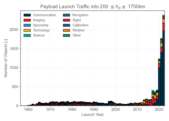
Figure 1: Number of objects launched into space per year, source: ESA Space Environment Report 2023[6].
However, not every satellite network delivers the same level of service. Performance varies depending on the orbit in which a satellite resides, making it essential to understand how distance from Earth affects its capabilities. The following section provides an outline of the three primary types of orbital classes, along with some of the principal trade-offs between them. It is important to note that LEO and MEO altitudes stated below are typical values that can sometimes vary in the literature. For instance, ITU issued a reference document on some of the major definitions used in radio communications[7].
2.1. Principal types of orbits
Here below are the main orbits used by satellites nowadays:
• Geostationary Orbit (GEO)
GEO satellites synchronize their movement with the Earth’s rotation, thereby staying fixed over a specific geographic location at an altitude of 35’800 km. GEO satellites have historically been used for services like weather monitoring, television broadcasting, surveillance, and low-speed data communications. In recent years, the capabilities of GEO satellites have been greatly enhanced by the introduction of High Throughput Satellites (HTS), specifically designed for data transmission.
• Medium Earth Orbit (MEO)
MEO satellites, typically operating at altitudes between 8’000 to 20’000 km, are primarily used for navigation (GNSS) and timekeeping applications, although some are used for telecommunication.
• Low Earth Orbit (LEO)
LEO space is currently populated with thousands of active satellites, mainly focused on scientific research, Earth observation, and telecommunication operating at an altitude between 400 to 2’000 km. The International Space Station also resides in a LEO, about 400 km to 420 km above Earth’s surface.
While the historical roles of GEO, MEO, and LEO satellites were relatively well-defined and separated, new trends are blurring these lines. Satellites in all three orbits are becoming more versatile, capable, and integrated, fuelled by technological innovations and growing commercial interests.
| GEO | MEO | LEO | |
| Altitude | 35 800 km | 8 000-20 000 km | 400-2 000 km |
| Orbital period | 24 hours | 4-12 hours | 1-2 hours |
| Footprint | Large | Medium | Small |
| Satellite cost | High | Medium | Low |
| Satellite lifetime | Long | Long | Short |
| Latency | Medium (~700 m/s) | Low (~150 m/s) | Very low (~50 m/s) |
| Earth coverage | Very large | Large | Small |
| Satellites required* | 3 | 6 | Hundreds |
| Gateways | Few and fixed | Regional and flexible | Local and numerous |
| Antenna | Stationary | 1-hour slow tracking | 10-minute fast tracking |
Figure 2: Overview of GEO, MEO, and LEO orbital characteristics. * For simultaneous global coverage.
Source ITU.
The figure below compares altitude and footprint of satellites on all three orbits.
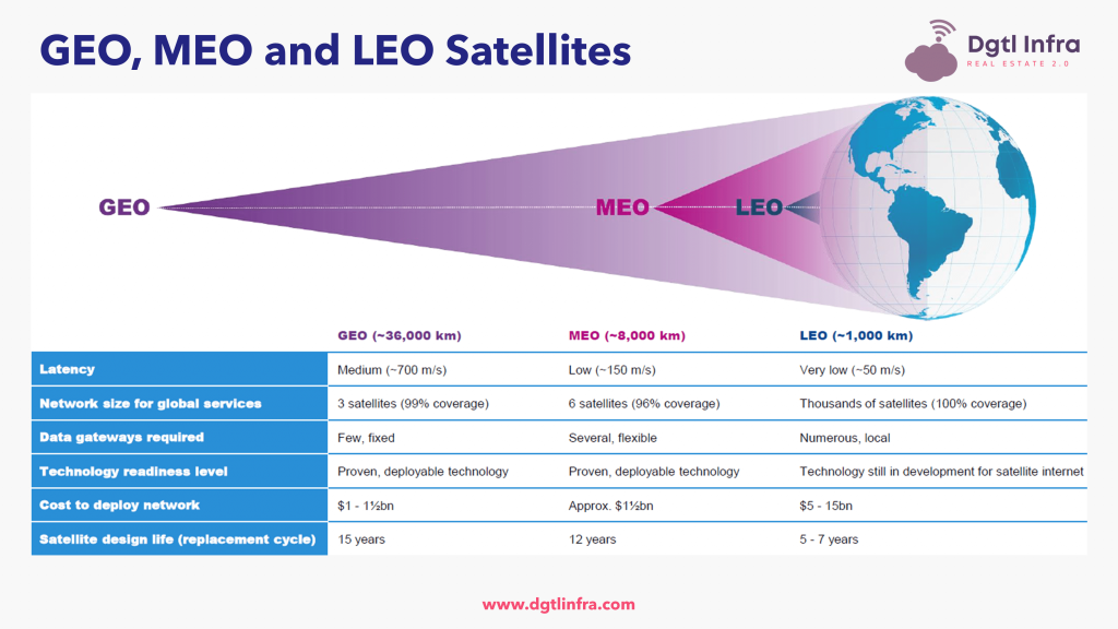
Figure 3: Comparison of altitude and footprint for GEO, MEO, and LEO satellites[8].
2.2 Satellite Infrastructure overview
A space-based infrastructure generally consists of three main components: the space segment, the ground segment, and the user segment[9]. The latter is composed of user terminals typically comprising an antenna and user equipment. The Space segment is composed of one or several satellites used to relay traffic between the gateway(s) and user terminals. The Ground segment is composed of one or more gateways (aka Ground Stations), which connect the satellite network to the internet or a private network.
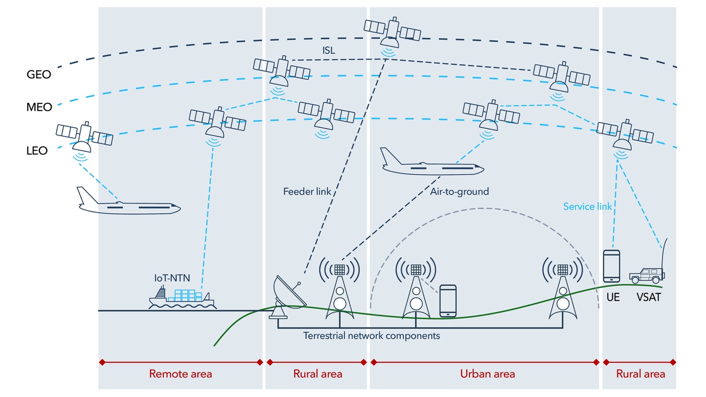
Figure 4: General connectivity overview of non-terrestrial networks.
Adapted from [10].
2.3 Frequency bands for satellite communications
Most satellite communication systems are radio frequency based. They typically operate within the radio bands of 1 to 40 GHz, but also in VHF/UHF as shown in Figure 5.
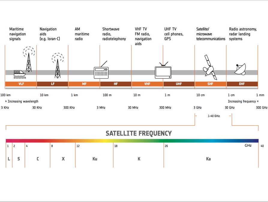
Figure 5: Overview of the radio frequency spectrum[11].
Here below are some traditional applications for each band:
• L-band (1–2 GHz) is mainly used for Global Positioning System (GPS) carriers and also satellite mobile phones and IoT;
• S-band (2–4 GHz) is used for weather radar, surface ship radar, and some communications satellites, especially those of NASA for communication with ISS and Space Shuttle;
• C-band (4–8 GHz) is primarily used for satellite communications, for satellite TV networks or raw satellite feeds;
• X-band (8–12 GHz) is primarily used by the military in radar applications. It is also used in civil and government institutions for weather monitoring, air traffic control, or maritime vessel traffic control;
• Ku-band (12–18 GHz) and Ka-band (26–40 GHz) are used for satellite communications.
Small satellites in LEO commonly use VHF, UHF, S, X, L, and Ka bands. However, higher frequencies generally experience greater atmospheric and rain attenuation. To counter these issues, either higher power transmission is needed, or antennas with higher gain and narrower beamwidths must be used, which requires more precise pointing for closing the link[12].
As for larger satellites, Ku-, K-, and Ka-band communication systems are considered cutting-edge, particularly for communications between spacecraft. These higher frequency bands are still emerging technologies within the CubeSat[13] domain but are gaining traction as lower frequencies become increasingly congested.
For Satellite Tracking, Telemetry, and Command (TT&C), the S-band is typically the go-to choice.
2.4. Overview of NGSO satellites applications
LEO and MEO satellites serve a wide array of functions, playing essential roles in our daily lives and global infrastructures. As mentioned earlier, LEO satellites, given their proximity to Earth have low-latency characteristics that supports real-time communication services. This includes not just voice and data services but also rapidly growing sectors like broadband internet access in rural or remote areas.
LEO satellites are particularly important in Earth observation applications too. They provide high-resolution images and rich data sets that meteorologists, environmental scientists, and urban planners rely on. These images are invaluable for everything from weather prediction and climate modeling to disaster response and recovery efforts. Furthermore, the perspective offered by LEO satellites helps in the surveillance and monitoring of military activities, making them vital tools for national security.
When it comes to scientific research, LEO is often the orbit of choice. In these orbits, satellites can more easily be retrieved, allowing for long-term experiments in microgravity. Such conditions are perfect for biological studies, materials science experiments, and even preliminary testing of technologies that may be used in deep-space missions[14].
MEO satellites offer their own set of advantages. Most notably, the Global Navigation Satellite Systems (GNSS), like the American GPS, Russian GLONASS, and European Galileo, operate in this orbit. These satellites provide the backbone for a multitude of navigation and timing services essential not just for personal navigation but also for sectors like aviation, maritime, and agriculture.
MEO satellites are also becoming increasingly useful in the field of communications. They offer a good balance between coverage area and latency, making them suitable for certain types of data and voice transmission. In some cases, they may complement LEO satellite constellations in providing more comprehensive and reliable global communication services.
Moreover, MEO orbits are being explored for scientific research. Satellites in this orbit can study the Earth magnetosphere, providing data that help us understand phenomena like the Northern and Southern Lights, as well as the solar winds and their interaction with Earth’s magnetic field. Such data is not only scientifically interesting but also crucial for understanding space weather events that can affect satellite operations and even terrestrial power grids.
Both LEO and MEO satellites are expected to play increasingly critical roles as we become more reliant on space-based assets.
2.5. Opportunities and challenges of NGSO satellites
Non-Geostationary (NGSO) satellites, orbiting in LEO, MEO or to a lower extent Highly Elliptical Orbit (HEO) offer the following opportunities:
• Coverage: NGSO constellations can offer more comprehensive global coverage, including in polar and remote areas where GEO satellites may have limited or no coverage due to their equatorial orbits;
• Latency: particularly those in LEO, have a latency similar to terrestrial networks due to their closer proximity to Earth, which is advantageous for real-time applications like video conferencing, VPN or cloud services;
• Resilience and flexibility: with multiple satellites in a constellation, NGSO systems can offer improved redundancy and resilience against system failures. NGSO satellites can also be more easily repositioned, making it possible to adapt to changing service demands or to respond to emergency situations more quickly;
• Cost: NGSO satellites operate at lower altitudes, which reduces the cost for launch. Their closer proximity to Earth also typically allows for smaller, lighter, and thus less expensive hardware. If the cost is low for one satellite, it is not necessarily the case for a full constellation, which often requires launching hundreds or thousands of satellites to offer service. This makes the cost of a NGSO satellite constellation generally higher than the cost of a GSO Very High Throughput Satellite (VHTS) for instance.
However, NGSO satellites have also a number of challenges:
• Infrastructure complexity: the management of a large NGSO constellation can be much more complex than handling a few GEO satellites, including the necessity for more advanced ground station technology for tracking multiple satellites;
• Lifespan: NGSO satellites, particularly LEO ones, tend to have shorter operational lifespans than GEO satellites due to residual atmosphere friction, leading to more frequent replacement needs;
• Maintenance: due to their shorter lifespans and larger numbers, NGSO satellites might require more frequent launches for replacements and updates, as well as more complex tracking and control systems to maintain their orbits, which could offset some cost advantages in the long term;
• Signal interference: with multiple satellites in orbit, there is a higher risk of signal interference among NGSO systems, requiring more sophisticated frequency coordination;
• Risk of space debris: larger constellations increase the risk of space debris, which could create complications for both the constellation itself and other space-based assets.
Some agenda items of the World Radio Conference 2023 (WRC-23), such as Item 7 partially addressed some of these challenges.
3. Space sustainability
3.1. Overview
According to UNOOSA, space sustainability can be defined as « the ability to maintain the conduct of space activities indefinitely into the future in a manner that realizes the objectives of equitable access to the benefits of the exploration and use of outer space for peaceful purposes, in order to meet the needs of the present generations while preserving the outer space environment for future generations.»[15]
This includes the preservation of orbital and spectrum resources, the protection of astronomical observations, and the security of communications. The following sections detail these different aspects of space sustainability.
3.2. Space debris
Space debris, also known as space junk, comprise non-functional artificial objects in Earth’s orbit, ranging from large rocket stages or defunct satellites to microscopic paint chips. The latest estimations evaluate the presence of over 36 500 space debris objects greater than 10 cm floating around through the Earth’s orbits; one million between 1 cm and 10 cm, and 130 million space debris objects whose size ranges from greater than 1 mm to 1 cm[16].
The time it takes for space debris to reenter Earth’s atmosphere is determined by its orbital altitude. Debris located below 600 km will typically take a few years to fall back to Earth, while objects situated above 1 000 km can remain in orbit for hundreds of years[17].
Most debris are in LEO, posing risks to both manned and unmanned spacecraft due to their high orbital speeds, making even small debris potentially catastrophic.
The growing number of satellites, especially mega-constellations, increases the risk of chain-reaction collisions, known as the Kessler syndrome, which could make LEO unusable one day. To mitigate this, and in the absence of legally binding international treaty that may take years to produce, space agencies, states and international organizations are adopting measures to foster best practices. Noticeable space debris mitigation guidelines have been edited by the European Space Agency (ESA)[18], the United Nations Committee On the Peaceful Uses of Outer Space (COPUOS)[19], the International Standard Organization (ISO)[20], the Inter-Agency Space Debris Coordination Committee (IADC)[21], and ITU[22] to name a few.
Generally, these recommendations can be categorized into three main areas:
• End-of-Life (EOL) disposal plans: both the Federal Communications Commission (FCC) and the European Space Agency (ESA) emphasize the importance of satellites having a well-defined end-of-life disposal strategy. This could involve naturally de-orbiting satellites to burn up in Earth’s atmosphere, or moving them to a designated “graveyard” orbit. ESA for instance recommends that “satellites and orbital stages be commanded to reenter Earth’s atmosphere within 25 years of mission completion, if their deployment orbit altitude is below 2 000 km (in the LEO region).”
• Collision avoidance: advanced maneuvers to avoid collision with existing space debris are strongly advised. This includes using more precise orbital parameters and possibly automated collision avoidance technologies.
• Material and design guidelines: it is recommended that new satellites and spacecraft be designed in a way that minimizes the creation of new debris. This can involve using materials that will disintegrate more easily upon re-entry, or designing components that are less likely to break apart.
Following the establishment of technical definitions and international standards, the subsequent phase involves translating these guidelines into concrete regulations. While some nations have already incorporated space debris mitigation by law (France) or by license (FCC license in the United States or orbital operator license in the United Kingdom), global adoption remains yet to be fully realized.
Last but not least, innovative solutions for active debris removal are being developed, using robotic arms or pliers to catch and dispose of space debris, either by burning them in the atmosphere or moving them to a graveyard orbit.
3.3. Dark and Quiet Skies Initiative
The Dark and Quiet Skies initiative is a joint activity of the United Nations, Spain and the International Astronomical Union (IAU) proposing recommendations which can eventually be acted upon either by local governments or agreed to at the international level.
It aims to preserve the night sky by mitigating the impact of artificial interference. These interferences can be organized into three distinct categories. The first type pertains to the consequences of emitting artificial light at night, commonly referred to as ALAN (Artificial Light At Night). The second type refers to the impact that the high volume of communication satellites in LEO has on astronomical observations. The third type focuses on the disturbances created by both ground-based and satellite radio broadcasting on radio telescope observations.
IAU working groups have produced a set of recommendations for the industry, the astronomy community, policy makers, and regulators. Some key recommendations to the attention of the latter are described in their report[23], this includes in particular:
• Formulate satellite licensing requirements and guidelines that take into account the impact on stakeholders, including astronomical activities, and that coordinate with existing efforts in relation to radio astronomy and space debris mitigation;
• Formulate licensing requirements that take into account the location of radio quiet zones and radio telescopes, such that satellites can avoid direct illumination of these areas;
• Investigate policy instruments that account for negative externalities of space industrial activities, including on astronomical activities, and develop incentives and inducements for industry and investors.
Through these various recommendations, the different stakeholders in the Dark and Quiet Skies Initiative aim to reach balanced, equitable solutions for preserving our night skies while still enabling technological progress.
3.4. Space Traffic Management (STM)
In February 2022, the European Commission initiated an action to boost management of space traffic for a more digital and resilient Europe[24]. The action plan includes an assessment of current STM civilian and military requirements and impacts for the European Union (EU), strengthening EU’s technological capability to identify and track spacecraft and space debris, setting out the appropriate normative and legislative framework, and establishing international partnerships on STM to engage at a multilateral level.
In parallel, the EU has implemented a Space Surveillance & Tracking capability (SST) as part of the Space Situational Awareness (SSA) component of the EU Space Programme (EUSPA), adopted by the EU in 2021[25]. In cooperation with other international organizations and space agencies, 130 European organizations benefit from the collision avoidance and re-entry analysis services by exchanging data on more than 260 EU satellites, including the Galileo and Copernicus fleets.
The rising number of space objects has spurred the need for SSA systems among space agencies and other organizations around the world, notably the North American Aerospace Defense Command (NORAD), the United States Space Surveillance Network (SSN)[26], the Indian Space Research Organization (ISRO)[27], and the Japanese space agency JAXA[28]. These organizations often collaborate and share data to improve the global tracking of artificial objects orbiting the Earth.
Some of these organization offer commercial service to satellite operators to track their satellites and receive early warning in case of a collision probability, so that collision avoidance maneuvers can be performed on time. Few private companies such as Leo Labs and Privateer also offer collision avoidance services to operators.
It is also worth mentioning initiatives like the French Space Operations Act (FSOA/LOS)[29] which aims at regulating authorizations and space licensing, setting out requirements relating to insurance and liability, and clarifying the domestic regime regarding remote sensing and intellectual property as it applies to space objects.
3.5. Sustainable use of spectrum
Radio frequency spectrum is a scarce resource and that the increasing demand for global communications is putting pressure on regulators. While the ITU supports and encourages technological progress in the space field, the increasing trend of filing non-GSO satellite systems in frequency bands that are not designated for the services they intend to provide poses significant risks of harmful interference for existing service operators.
To minimize this risk, all country administrations should manage the allocation of frequencies to Earth stations to prevent violation of the ITU’s table of frequency allocations and the ITU Radio Regulations (RR).
Also, satellite operators using frequencies under the derogation of the RR No. 4.4 to “not cause interference to, and shall not claim protection from harmful interference” may encounter challenges in obtaining national licenses for their satellite systems and corresponding Earth stations.
Member states should primarily use official ITU data, based on transparent, internationally recognized methodologies, and collaborate across regions to share expertise and resources, to prevent harmful interference between radio stations from different countries.
3.6. Security of satellite telecommunications
Threats to satellites emanate from the fact that their embedded computer systems -whose role is also to facilitate remote setup and upgrades- are vulnerable to cyberattacks. Secondly, a sizeable number of satellites are meant to have very long lifespan, which means that their technology will ultimately become outdated. Considering the rate at which technology keeps changing, it will always be a challenge to find a timely remedy to space cyber-threats. Below are the 4 main types of cyber-attacks that pose significant threats to satellite telecommunications:
• Jamming refers to a situation whereby the signal of the satellite is flooded or overpowered through an attack. These kinds of attack are usually targeted at global navigation satellite systems (GNSS). These systems contain accurate clocks and broadcast timing data necessary for proper functioning of crucial everyday applications. For example, an attack on these systems can cripple a mobile-phone network.
• Spoofing is more of an advanced level of jamming since it entails replacing a flooded signal with a fake one. Used in combination, jamming and spoofing attacks have the potential to bringing down critical systems like power grids, financial systems and a number of other infrastructures.
• Eavesdropping makes it possible for an attacker to obtain transmitted data. Although nearly all satellite communications are encrypted, it is not difficult to find readily available software to intercept satellite transmissions regardless of whether they are transmitting telephone data, satellite broadcast media or Internet data.
• Denial of Service (DoS) attacks overload satellite communication channels or systems to make them unavailable for legitimate users. NGSO satellites may be particularly vulnerable to this type of attacks due to their limited computational power that makes it easily overloaded with processing tasks.
It is important to note that there is a ceiling in terms of how much commercial satellite operators can protect their communications. Even though encryption remains a useful and economical procedure that can be used by any satellite operator, telemetry datalinks usually make use of local networks which are more vulnerable. Overall, some of the systems that are exposed to cyber-attacks include operations of the space and ground segments, Tracking, Telemetry and Command (TT&C) processes, uplink and downlink communications and network performance.
The primary countermeasures[30] to ensure the security of satellite infrastructures include encryption of transmission signals, the use of authentication protocols, regular security updates, and strengthening the other constituents of satellites infrastructures such as the ground stations. But in order to manage these measures, supplementary hardware capabilities are often required, which also comes with consequences in terms of cost for the systems, their general weight, the maintenance activities and the overall platform’s performance.
4. Current status of NGSO satellite constellations
Satellite constellations for broadband connectivity, comprising both LEO and GEO systems, are drastically changing how the world connects to the internet. While LEO constellations offer high-speed, low-latency coverage, especially valuable in remote and hard-to-reach areas, GEO satellites provide stable, wide-area coverage essential for broadcasting and long-range communications.
Together, they offer a robust and versatile network that can serve a variety of needs, from rural connectivity to global data transmission. GEO constellations are particularly important for providing consistent and reliable service over large geographic areas. Combining the strengths of both LEO and GEO systems allows for a more resilient, efficient, and far-reaching broadband network.
As the need for global connectivity continues to grow, these satellite constellations will play a pivotal role in shaping the future of digital communication.
4.1. Examples of satellite constellations for broadband connectivity
In the last decade, legacy satellite broadband operators have seen their leadership being challenged by new entrants and an ever-growing demand for fast and global internet access. This section presents some of the main players in LEO for which public and corporate information is available.
SpaceX’s Starlink
Managed by the U.S.-based aerospace firm SpaceX, Starlink offers satellite internet services across more than 40 nations, particularly in areas where connectivity is poor, unreliable, or completely unavailable. The constellation is designed to operate in LEO, at an average altitude of 550 km, using Ku/Ka bands. The initial deployment of Starlink satellites began in 2019, and by September 2023, the network has grown to include over 4 692 small-scale satellites[31]. In total, nearly 12 000 satellites are planned to be deployed, with a potential future expansion to 42 000. SpaceX announced that Starlink had surpassed 1.5 million users in May 2023. In Aug 2022, SpaceX and T-Mobile announced a partnership to bring satellite connectivity to mobile phones[32].
OneWeb
Planned to comprise a total of 648 (600 operational + 48 reserve) satellites in LEO, the constellation is designed to offer a wide coverage area and low latency communication. As of today, the company has launched 636 satellites, 632 of which are functional[33]. These satellites are positioned at an altitude of approximately 1 200 km, and operate using Ku-band radio frequencies.
OneWeb’s commercial service is anticipated to commence in the fourth quarter of 2023. In January 2021, OneWeb amended its application with the FCC to change the number of satellites planned for its Phase 2 constellation to 6 372.
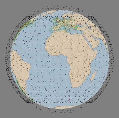

Figure 7: Starlink (left) and OneWeb (right) constellations as of September 2023[34].
Iridium NEXT
Replacing the original Iridium constellation, Iridium NEXT consists of 66 operational cross-linked satellites in LEO that ensure global coverage, including remote and polar areas. The system uses L-Band to communicate with ground users and K/Ka-band for inter-satellite links and to communicate with gateways. The system was fully deployed by January 2019, with satellites operating at an altitude of approximately 780 km. The constellation offers voice and data communication services and also supports specialized applications such as asset tracking, maritime communication, and emergency services. In January 2020, the Iridium constellation was certified for use in the Global Maritime Distress and Safety System (GMDSS)[35].
In addition, each Iridium-NEXT satellites can host a 50 kg secondary payload which is used for instance to deploy Automatic Dependent Surveillance-Broadcast (ADS-B) receivers that provide global and continuous space-based monitoring and control of aircraft[36].
Telesat Lightspeed
Lightspeed, a constellation project undertaken by Canadian company Telesat, aims to deploy a network of 198 LEO satellites operating at altitudes around 1 000 to 1 300 km. This next-generation network is designed to deliver ultra-high-speed, low-latency internet to various sectors including aviation, maritime, and remote communities.
Telesat Lightspeed will leverage advanced phased-array antennas and optical inter-satellite links to ensure seamless and reliable communication. Although launches are slated to start in the middle of 2026, the system is already supporting live demonstrations across a variety of markets and applications after the successful launch of Telesat’s Phase 1 LEO demonstration satellite in January 2018[37].
SES O3B
The O3b[38] constellation is a high-throughput, low-latency satellite network operated by SES, a global satellite operator based in Luxembourg. O3b uses Ka-band for its user, gateway, and TT&C links. Launched initially in 2013, the constellation operates in the MEO at an altitude of around 8 000 km. The initial constellation of 20 satellites has been since complemented with four mPower 2nd generation satellites, with an aim to launch 11 in total[39].
Designed with advanced beamforming capabilities, the satellites can focus bandwidth on specific geographical regions for optimized service. The system serves multiple sectors, including maritime, aviation, and government, offering services like cloud connectivity and secure data transmission.
Amazon Kuiper
Amazon’s Project Kuiper is an initiative aimed at deploying a satellite constellation to provide broadband internet service globally. Spearheaded by one of the world’s largest tech companies, Amazon, the project aspires to bridge the digital divide by offering connectivity to underserved and remote regions. The plan involves launching 3 236 LEO satellites, which will operate in the Ka-band spectrum on three orbital shells, at 590 km, 610 km, and 630 km.
Under its FCC license granted in 2020, Amazon is required to launch and operate 50% of its satellites no later than July 30, 2026, and must launch and operate the remaining satellites no later than July 30, 2029[40]. Amazon plans to launch the first two protype satellites “KuiperSat-1” and “KuiperSat-2” as soon as September 26, 2023[41].
Iris2
IRIS2, which stands for Infrastructure for Resilience, Interconnectivity and Security by Satellite, is a satellite internet constellation that the European Union plans to launch by 2027. The network aims to serve both governmental bodies and commercial enterprises. Created as the EU’s answer to growing satellite internet systems beyond its jurisdiction, like Starlink and the upcoming Kuiper project, IRIS² is designed to roll out in stages, with a goal to initiate services by 2024 and achieve full operational status by 2027. In May 2023, a consortium composed of Airbus Defense and Space, Eutelsat, Hispasat, SES, and Thales Alenia Space signed a partnership agreement to bid for the IRIS2 constellation[42].
Globalstar
The Globalstar constellation is a satellite network designed primarily to provide mobile satellite voice and data services across the globe. Operated by Globalstar Inc., the system initially launched in the late 1990s has since undergone various upgrades. Today, the constellation comprises 48 LEO satellites that operate at an altitude of approximately 1 414 kilometers[43] in S/L bands. These satellites facilitate a range of communications services, including voice calls, data transmission, commercial IoT, and SPOT tracking that serve a multitude of companies, remote workers and adventurers.
| Operator | Satellites (Planned/deployed) | Altitude | Frequency band | Operational |
| SpaceX Starlink | 42 000 / 4 692 | 550 km | Ku/Ka-band | Yes |
| OneWeb | 648 / 636 | 1 200 km | Ku-band | Q4 2023 |
| Iridium NEXT | 66 | 780 km | L-band | Yes |
| Telesat Lightspeed | 198 / 0 | 1 000-1 300 km | C/Ku/Ka-band | 2026 |
| SES O3b | 31 / 24 | 8 000 km | Ka-band | Yes |
| Amazon Kuiper | 3 236 / 0 | 590-630 km | Ka-band | No |
| Iris2 | TBD | TBD | TBD | 2027 |
| Globalstar | 48 | 1 414 km | L/S-band | Yes |
| Galaxy Space | 1000 / 7 | 480 km | Q/V/Ka-band | TBD |
| Orbcomm | 44 | 825 km | 137-150 MHz | Yes |
Table 1: Overview of LEO broadband service providers.
| Smart Villages and Smart Islands Initiative (SVSI)NGSO satellites are expected to play a crucial role in bridging the digital divide, providing much needed communication means to underserved or unserved populations. Latest figures show that an estimated 5.3 billion people of the Earth’s 8 billion are using the Internet in 2022, or roughly 66 per cent of the world’s population. According to the joined ITU-UNICEF GIGA Initiative, more than 1 billion children struggle to learn without quality broadband access to the Internet at home, and only half of the world’s schools are online[44]. This is especially true for small islands which often suffer from geographic isolation, lack of human resources, and low availability of infrastructure.The ITU Smart Villages and Smart Islands initiative[45] aims to enhance the well-being and livelihoods of residents in developing countries and in particular Small Island Developing States (SIDS) by providing scalable, sustainable digital services. The initiative is based on the ITU-ANSI Smart Villages model and focuses on improving broadband connectivity, affordability, digital skills, and service provision. The project addresses challenges unique to SIDS, such as geographic isolation and limited infrastructure, directly contributing to the Sustainable Development Goals.The model is demand-driven and focuses on multi-sector collaboration. It aims to impact various sectors including health, through telemedicine; education, by offering distance learning; and agriculture, by deploying specialized apps for farmers. Additionally, the project supports multi-hazard early warning systems, digital financial services, and aims to boost tourism through e-commerce. In March 2024, the initiative is foreseen to operate in 15 SIDS across the Asia-Pacific region.Isolated villages and islands have specific requirements that only NGSO satellites can achieve. This includes self-installation and low maintenance of the terminals, as well as ease of use and transport. For instance, in case of a typhoon approaching, it is easier to deinstall a NGSO terminal, shelter it and place it back on when the treat is over, than it is for a GSO large parabola. In such emergency event, regulators may issue temporary licenses to services like Starlink, Viasat, O3b.Although most applications don’t require yet the low latency brought by NGSO (e.g. banking, education, telemedicine), once villages and islands become more digital savvy, more applications will develop, some requiring instant connections such as emergency alerts, video conferences, or instant translations to ease communication between communities that sometimes don’t speak the same language within the same country. |
4.2. Satellite constellations for narrowband connectivity (IoT, M2M)
Satellite Internet of Things (IoT) or Machine-to-Machine (M2M) refers to the integration of satellite communication technology with IoT devices, enabling data transmission and connectivity in areas beyond the reach of traditional terrestrial networks. Unlike regular IoT setups that rely on Wi-Fi, cellular, or other ground-based networks such as LoRa or NB-IoT, satellite IoT uses satellites to facilitate the exchange of information between sensors, devices, and control systems.
This approach offers several advantages, such as global coverage and the ability to connect devices in remote or inaccessible locations like deserts, oceans, or even the polar regions.
Satellite IoT is particularly valuable for industries like agriculture, maritime, logistics, oil & gas, and environmental monitoring, where assets or points of interest are often scattered across wide areas. It allows for the tracking of ships in the open sea, monitoring soil conditions in large farms, or even tracking wildlife in conservation efforts.
While satellite connectivity is not new, it used to be cost prohibitive for IoT application, this is no longer the case today. The NewSpace approach has drastically lowered barriers to entry for satellite-based services, mainly due to the use of affordable Commercial Off-The-Shelf (COTS) components for nanosatellites and lower launch cost.
The global satellite IoT connectivity market reached USD 511.2 million in 2021 and is projected to reach USD 969.6 million by 2026[46].
Incumbent satellite companies like Inmarsat, Iridium, ORBCOMM, and Globalstar currently account for over 80% of the worldwide revenue in the satellite IoT connectivity market. Nonetheless, emerging companies that provide affordable and power-efficient IoT connectivity via LEO satellites start offering competitive services. These include Myriota, Kineis, and Fleet to name a few.
Specificities of satellite IoT systems
Satellite IoT represents a significant shift from traditional satellite services primarily designed for human communication and broadcasting. Unlike these conventional services, satellite IoT networks are optimized for narrowband, short-burst data transmissions (up to a few kB) and focuses on connecting a multitude of smaller devices scattered across vast or remote areas. Here are some of the most critical aspects of satellite IoT systems:
• Modules with low-power consumption as satellite IoT devices often operate in environments where it is impractical to change or recharge batteries. LEO is the orbit of choice here as its lower distance to Earth means lower signal propagation losses and therefore lower power consumption;
• Security and reliability of communications is essential, especially for sensitive or critical infrastructures;
• Bidirectionality & Over-The-Air (OTA) capability are key features too, as these enable sending commands and firmware updates to remote devices without the need for human presence on site. This can be helpful to turn on and off a water irrigation system for instance;
• Latency of messages (the time it takes between sending a message from a device in the field and receiving it on the user portal) has a great impact on applications that can be served. For instance, a 1-hour service latency may be fine for glacier displacement monitoring while it is not for vehicle tracking;
• Direct-to-Orbit vs Gateway systems. A direct-to-orbit solution requires a transmitting device per asset to be monitored or tracked, while a gateway solution would first aggregate data from a fleet of assets before transmitting it to the satellite. Depending on the use case, each have their own pros and cons[47].
4.3. Emergency warning satellite systems
Satellite services can act as a quick fallback when terrestrial networks fail, such as during natural disasters, to maintain network access for affected populations. These satellite solutions are typically temporary measures until mobile or fixed networks are restored. Pre-planning and having satellite terminal equipment on standby are essential for rapid deployment to areas in need. The following sections details some initiative and services in this regard.
4.3.1. EW4ALL Initiative
Progress in early warning systems have been instrumental in preserving countless lives and avoiding significant economic losses. However, as of the year 2022, only 50% of nations worldwide benefit from such comprehensive early warning systems. The figures are even lower for developing nations: less than half of the world’s Least Developed Countries (LDC) and merely one-third of Small Island Developing States (SIDS) are equipped with a multi-hazard early warning system.
In March 2022, the UN Secretary-General initiated the Early Warnings for All campaign[48] (EW4All), with the ambitious goal of extending early warning system coverage to every individual on the planet by 2027. The action plan is composed of 4 pillars spanning from disaster risk knowledge to detection, dissemination of information and preparedness to respond.
NGSO satellites, like those operated by Planet, are crucial for Earth monitoring, providing daily high-resolution images of almost every place on Earth[49].
As for communicating alerts, ITU promotes a multi-channel approach including sirens, radio, social media, television, SMS, or phones[50]. Today 95% of the global population has mobile broadband access and three out of four people around the world own a mobile phone. However, in some places with bad infrastructures or in cases of emergencies disrupting networks, satellites often remain the only communication option. This is why ITU advocates for a broader adoption of mobile devices capable of communicating with emergency warning satellite systems, particularly low-cost, satellite-enabled, mobile phones.
4.3.2. Cospas-Sarsat
The Cospas-Sarsat service is an international satellite-based search and rescue system designed to provide timely and accurate distress alert and location data to assist in the rescue of people in emergency situations. Originally initiated in 1979 by Canada, the United States, France, and the former Soviet Union, it has since grown to involve many other countries and has saved thousands of lives worldwide. The system operates 24/7, ensuring continuous availability for search and rescue operations on land, at sea, and in the air.
Cospas-Sarsat utilizes a network of ground stations and satellites in different orbits, including GEO, MEO, and LEO, to detect and locate signals emitted from emergency beacons in the 406 MHz band. These beacons can be personal, aeronautical, or maritime and are activated manually or automatically in distress situations. Once a beacon signal is detected, the system forwards the information to rescue coordination centers, which then initiate rescue operations.
The service is freely accessible to anyone, regardless of nationality or location, and doesn’t require a subscription. Advances in technology, like the integration with the European Union’s Galileo system, continue to enhance the service capabilities, improving the accuracy and speed of its operations. For instance, since 2020, it features a unique “return link service,” which confirms to the person in distress that their signal has been received and help is on the way[51].
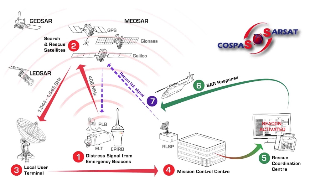
Figure 8: Cospas-Sarsat system architecture overview[52].
5. Regulatory landscape and the role of institutions
Efficient spectrum use is among the most critical challenges that the international satellite community must address to alleviate interference created by NGSO systems. Collaboration and information exchange among regulators, astronomers, and the industry is key to develop industry best practices and standards to secure the long-term viability of both ground-based astronomy and satellite constellations. The sections below present the role of the different stakeholders, examples of best practices and regulatory challenges related to NGSO systems.
5.1. Overview of the main stakeholders
Sustainability has become a key issue for all stakeholders of the space sector. Given the rapid pace at which the sector develops, it is essential for national frameworks to find the right balance between the interests of private companies and governments on one hand, and safeguarding ongoing space activities at international level on the other hand.
Globally, the United Nations international entities like the United Nations Office for Outer Space Affairs (UNOOSA) or ITU establish overarching guidelines and principles. Regional bodies, such the European Space Agency (ESA), adapt these principles to coordinate policies and actions suited to their specific contexts and member states. National agencies, like the Agence Nationale des Fréquences (ANFR), the Telecom Regulatory Authority of India (TRAI) or the UK Space Agency, implement and comply with these standards, considering global and regional inputs while tailoring policies to meet domestic needs and objectives. Continuous dialogue, collaboration, and negotiation among these regulatory levels ensure coherent and effective governance, fostering sustainable and responsible use of outer space. During the 2022 International Astronautical Congress (IAC) in Paris, a research paper[53] mapped the roles and interactions of the main space stakeholders, highlighting the rising complexity of the ecosystem, as seen below.
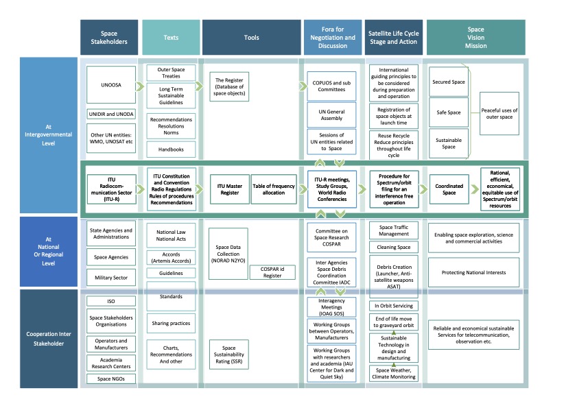
Figure 9: Overview of space sustainability stakeholders53.
The figure below shows how the ITU tools coexist with other stakeholder’s frameworks.
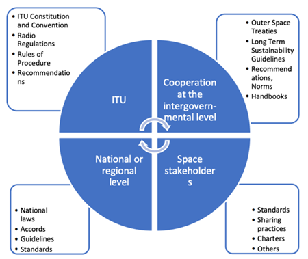
Figure 10: Texts and regulatory frameworks for space sustainability53.
5.2. International regulations on the use of radio spectrum and orbital resources
5.2.1. ITU Radiocommunication Sector
Operating through its Radiocommunication Sector (ITU-R)[54], ITU sets international regulations and standards for technical and operational dimensions of space-based systems. ITU Member States have established a legal regime, which is codified through intergovernmental treaties: the ITU Constitution and Convention, the Radio Regulations, Recommendations, and other Handbooks. These instruments contain the main principles and lay down specific regulations governing the following major elements:
• Frequency spectrum allocations for different categories of radiocommunication services (Space, terrestrial, maritime, radio astronomy)[55];
• Rights and obligations of national administrations in obtaining access to the radio spectrum and associated orbit resources;
• International recognition of these rights by recording frequency assignments and, as appropriate, associated orbital positions used or intended to be used in the Master International Frequency Register. The above regulations are based on the main principles of efficient use of and equitable access to the spectrum/orbit resources laid down in the ITU Constitution.
In the case of NGSO satellite networks, there are two distinctive regulatory procedures to record assignments and obtain protection to operation free from harmful interference[56], depending on whether a coordination with other operators of systems is required or not, as shown below.
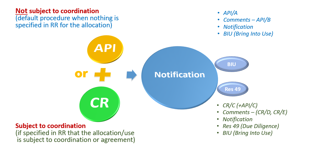
Figure 11: ITU’s procedures for NGSO spectrum allocation, either through Coordination Request (CR) or Advance Publication Information (API)56.
Furthermore, ITU serves as a platform for dialogue and dispute resolution, involving member states and various stakeholders (193 Member States and over 900 Sector Members i.e. companies or academia). It assists in solving conflicts related to spectrum and orbital allocations, promoting a cooperative global environment.
The presence of NGSO systems in the ITU’s Radio Regulations spans over six decades. Since their introduction, NGSOs have been an integral part of the ITU’s framework, reflecting the evolving nature of satellite communication and its importance in global connectivity. The ITU has continually updated its regulations to accommodate the dynamic challenges and capabilities of these satellites, ensuring that they coexist harmoniously with other existing systems. This evolution continued with WRC-23 as shown in a following section.
5.2.2. UN COPUOS/UNOOSA
The UNOOSA and the Committee on the Peaceful Uses of Outer Space (COPUOS) has a central role in the international governance of space activities. UNOOSA serves as the secretariat for COPUOS, facilitating dialogue and cooperation among member states on space-related matters. Their work encompasses issues such as space law, space science and technology, and the sustainable use of outer space resources.
COPUOS, through its subcommittees on Scientific and Technical Matters and Legal Matters, is instrumental in developing international space treaties and principles, aiming to ensure that space activities are conducted for the benefit of all humanity. UNOOSA also plays an expert role in capacity-building for developing countries, offering them opportunities to access to space science, technology, and applications, and develop national space law.
As satellite costs and technologies have advanced, an increasing number of countries have gained access to space, with universities and start-ups spearheading the development of small satellites. Consequently, nations are prompted to establish their own space laws to align with international regulations. Under the 1967 Outer Space Treaty, a State is internationally responsible for all its activities in outer space, whether conducted by governmental or non-governmental entities. This includes the requirement to register any object launched into space with the UN’s Secretary-General, as per the 1976 Registration Convention or UN General Assembly Resolution 1721B (XVI). For this purpose, UNOOSA provides registration forms in all UN languages to assist in this process[57]. It is important to note that launch providers often require a proof of registration by the satellite operator before launching their satellites into orbit.
Finally, in May 2023, UNOOSA published the space Policy Brief 7[58], which provides insights and recommendations to UN Member States and entities.
5.3. Regional regulations
The European Conference of Postal and Telecommunications Administrations (CEPT) serves as the coordinating body for telecommunications and postal services across Europe bringing together national regulatory authorities from 46 European countries to facilitate harmonized policies, strategies, and standards in these sectors. CEPT operates through committees, like the Electronic Communications Committee (ECC), which focuses on radio communications or the European Communications Office (ECO), which provides advice to deliver policies and decisions. Through ECC and ECO, the CEPT provides satellite regulation information[59] such as:
• A list of contact points in CEPT administrations concerning satellite related enquiries, including links to the national satellite regulatory regime where available;
• Access to a number of harmonization decisions on the exemption from licensing and free circulation of satellite terminals for the use of Earth Stations in Motion (ESIM) in order to provide connectivity on board aircraft, ships and vehicles across borders;
• A framework for satellite IoT/M2M communications that identifies specific UHF/VHF frequency bands exempt of licensing, allowing new operators to operate in CEPT administrations which implement these decisions without the need for individual licensing.
In the Americas region, the Inter-American Telecommunication Commission (CITEL) , operating as an entity under the Organization of American States (OAS) that comprises all 35 independent states of the Americas[60], recommends its administrations to adopt a generic or blanket licensing framework for ESIM operations in particular frequency bands.
The South Asian Telecommunication Regulators’ Council’s (SATRC)[61] Working Group on Policy and Regulatory Services as part of its action plan Phase VIII (2022-2023), is preparing a report on “NGSO satellite constellations: Requirements, challenges and impact in South Asia”, aiming at providing a consolidated overview of NGSO constellations for its member states.
5.4. Market entry and national approaches
In the dynamic realm of the satellite industry, establishing a successful market presence requires not only groundbreaking technology and innovative services but also a deep understanding of the regulatory landscape. Some of the critical facets of market entry are detailed below, focusing on selected examples of national licensing regimes for the provision of telecom services via satellites.
Federal Communications Commission (FCC), United States
The FCC is the primary regulatory body overseeing satellite communications in the United States. It is responsible for licensing both commercial and non-commercial satellite systems, including those in GEO and NGSO. The FCC manages the radio frequency spectrum and sets technical and operational standards to promote safety and reliability in satellite communications. Operators must submit detailed applications outlining their satellite systems, including technical specifications and orbital parameters. The FCC evaluates these applications to ensure they meet regulatory criteria, such as orbital debris mitigation and spectrum allocation. Once approved, operators are granted access to specific frequency bands and orbital slots. In 2023, the FCC created the Space Bureau[62], intended to replace the earlier International Bureau in conjunction with the Office of International Affairs (OIA). The Space Bureau leads in policy formulation and licensing for satellite and space-based activities, streamlining regulatory processes and ensuring efficient use of spectrum and orbital resources. The Bureau authorizes satellite and Earth station systems and coordinates with other U.S. government agencies on space-related issues.
In August 2023, the FCC proposed a set of new licensing reforms to keep up with the fast-paced satellite industry. According to the announcement[63], the proposed order would streamline the licensing process and encourage innovation. For instance, it suggests eliminating the procedural burden of printing and maintaining a paper copy of a license. A new rule provision would also allow Earth station operators to apply for and receive a limited license under the condition that the license will require modification prior to operations. Finally, certain minor modifications could be made by operators without prior authorization from the FCC.
Office of Communications (Ofcom), United Kingdom
Ofcom is the United Kingdom’s regulatory authority overseeing broadcasting, telecommunications, and postal services, also including satellite communications. In the context of satellite communications, Ofcom plays a central role in licensing satellite services and operations within the UK’s jurisdiction.
Ofcom introduced[64] a new NGSO licensing framework, in December 2021, defining two types of licenses[65]:
• NGSO Network License usually held by the satellite operator;
• NGSO Gateway License, held by the entity having control over the gateway, usually the satellite operator or the teleport operator.
NGSO Gateway licenses can be used within the national territory of the emitting country but restrictions may apply around sensitive sites. Licenses are leasable and transferable, which means that operators can also access the spectrum through commercial agreements with the license holders.
The regulatory process aims at checking if the licensed system can coexist with other existing services and allow for a public period of comments where all stakeholders can indicate potential interference or competitive impact. It is up to the new applicant to provide evidence that coexistence with existing services or previous applicants is possible. The evidence can come in the form of an ITU coordination agreement or a detailed explanation on how the applicant and existing licensees plan to coexist.
In addition, Ofcom enforces regulatory compliance among satellite service providers, including safety and quality standards, and has the authority to impose fines and sanctions on companies that breach these regulations.
NGSO Network licenses authorize the use of user terminals with the satellites. Ofcom have specific requirements regarding Network licenses, which come in addition to the ITU Radio Regulations. For instance, in order to avoid artificial scarcity of spectrum, Ofcom requires that operators commence and maintain transmission within 12 months following the granting of licenses.
Agence Nationale des Fréquences (ANFR), France
ANFR, or the National Frequency Agency, is the French regulatory body responsible for managing the radio frequency spectrum in France. The agency is tasked with planning, allocating, and monitoring frequency bands used for wireless services and satellite operations within French territories[66]. In the domain of satellite communications, ANFR also ensures that the allocated spectrum is used efficiently and that there is minimal interference between different operators and services.
ANFR published a guide for SMEs and Startups that would like to use or deploy satellite systems[67]. The first step is the filling of a frequency assignment request by the requesting entity using the ITU’s SpaceCap software. This request includes frequency ranges, bandwidth, satellite equipment details, launch altitude, and inclination. ANFR then verifies and submits the request to ITU on behalf of the applicant, ensuring project compliance with the intended radiocommunication service and avoiding overlap with military-exclusive bands. ITU identifies potentially affected administrations and notifies the global community via an API/A. Other countries have four months to provide feedback to the French administration. ITU then publishes a list of countries with which negotiations must take place (API/B). The satellite operator, with the help of ANFR would then prepare answers to the requesting administrations. When international coordination is complete, the next step involves informing other countries of the chosen technical parameters, submitted to ITU for international recognition. Frequency registration occurs no sooner than 6 months after the publication date. The final step is the issuance of ministerial authorization to transfer France’s rights and obligations toward ITU to the satellite operating company.
Department of Information and Communications Technology (DICT), Philippines
In 2021, the Philippines’ Department of Information and Communications Technology (DICT) released Executive Order No. 127, otherwise known as the Expanding the provision of internet services through inclusive access to satellite services[68]. It states that all Satellite Systems Providers or Operators (SSPOs) who desire to provide satellite services in the Philippines shall have a digital presence accessible in the country (i.e., a website) and a local presence (foreign SSPOs must have a branch office, representative office, institutional agent, official distributor, or a combination thereof).
Additionally, to ensure universal access to quality, affordable, reliable, and secure ICT services, the government of the Philippines encourages the propagation, deployment, and use of modem satellite and other emerging technologies by allowing Internet Service Providers (ISPs), value-added service providers, and enfranchised or public telecommunications entities duly registered with the National Telecommunications Commission (NTC) to directly access all satellite systems duly accredited in the country.
Uganda Communications Commission, Uganda
A local presence and liability of satellite operators in case of customer complaints is also promoted by Uganda, where a radio frequency spectrum authorization to facilitate space communication activities or needs shall only be granted to a company duly incorporated in Uganda or a statutory body established under the laws of Uganda, and in accordance with sections 21, 25 and 26 of the Uganda Communications Act 2013[69].
India
Establishing a satellite-based communication service or network in India necessitates close collaboration among various government entities including the Department of Space, Ministry of Information & Broadcasting, and Department of Telecommunications. Key permissions involve service licensing from the Department of Telecommunications (including a Unified License for Global Mobile Portable Communication by Satellite (GMPCS)[70]), space segment assignment through the Department of Space, frequency assignment from the Wireless Planning and Coordination Wing, and carrier plan approval from the Network Operations and Control Center. The Telecommunication Engineering Center plays a role in issuing and modifying relevant standards and interface requirements. An Inter-Ministerial Committee for Satellite Network Clearance consolidates these entities, facilitating a unified platform for issuing preliminary clearances to proposed networks.
Agência Nacional de Telecomunicações (ANATEL), Brazil
According to ANATEL regulations, the operation of satellites in and from Brazil must be carried out exclusively through the frequency bands allocated to satellite services compatible with Brazilian telecommunications services. The operation of satellites associated with fixed satellite, mobile satellite and broadcasting satellite services is subject to a satellite landing right authorization, which grants operators the right to use specific spectrum and orbital positions to perform satellite communications and to provide satellite capacity to interested third parties for a duration of up to 15 years.
ITU best practices
Based on ITU Radio Regulations and recommendations (see guidance on the regulatory framework for national spectrum management in report ITU-R SM.2093[71]), Member States have the authority to establish their own domestic rules for the use of frequency spectrum. Each country is responsible for managing its radio-frequency spectrum in a manner that is rational, efficient, economical, and fair. This should include robust security and monitoring systems, as well as measures to prevent interference within their national borders, all aimed at serving the best interests of their population.
Although this flexibility at national level can have significant benefits for consumers, it may result in challenges for satellite operators, especially for the provision of services at the international level. Enhanced communication and cooperation between countries could mitigate this issue, potentially through the establishment of common regional or international platforms.
The ITU supports the roll-out of NGSOs by promoting regulatory best practices[72] [73] for national regulators and policy makers, which include:
• adhering to the principles of the ITU Constitution, Convention, and Radio Regulations when promulgating national policies, regulations, legislation, or licensing frameworks;
• encouraging the deployment of innovative and competitive technologies and service models;
• maintaining technology-neutral goals and policies by stimulating and supporting transparent and complementary use of terrestrial and space system for all types of applications;
• cooperating and building a common understanding at the international level on issues surrounding anti-competitive behaviors and converge towards a certain level of regional harmonization in view of spearheading innovation and investment in digital;
• publicizing policies to promote social inclusion;
• facilitating service rollouts and fair coexistence among all competitors;
• working closely with the international multi-stakeholder community as well as with other national and foreign regulators on transboundary issues.
On the spectrum policy and licensing side, good practices include:
• adherence to ITU Radio Regulations and relevant coordination procedures when creating domestic regulations;
• ensuring that changes to spectrum allocations/licensing are handled in a timely manner as such changes cannot be technologically and operationally easily adapted in a short- to medium-term for operators;
• fairness regarding spectrum access: incumbent users of spectrum allocations need time to switch to different spectrum. Any changes must allow time for studies done by relevant groups (i.e., regulators, academia, operators, including public consultations);
• fostering harmonization of international and regional spectrum allocations to create economies of scale, roaming and interoperability.
Regulatory challenges for satellite operators
As a satellite operator, it is important to pay attention to a set of pre-conditions in order to offer satellite-based communication services. The Body of European Regulators for Electronic Communications (BEREC)[74] highlights a few:
• Frequency Authorization: This can come in different forms, such as individual authorization for specific satellite networks, a general, license-exempt authorization, or an authorization by appropriate reference to the frequency utilization plan as per ITU’s Radio Regulations;
• National Regulations: Operations must comply with national telecom laws and universal service regulations, which may include legal intercept requirements and routing customer data through specific gateways;
• Legal Challenges: In some countries, the authorization process may involve public consultations or checks for non-European operators;
• Equipment Conformity: Satellite communication equipment, including end-user terminals, are often subject to regulations like the Radio Equipment Directive 2014/53/EU[75];
• Coordination Requirements: Some administrations may require that satellite networks are fully coordinated with existing satellite and terrestrial networks before granting authorization. CEPT/ECC technical studies[76] aimed at avoiding interferences are here to help in this regard.
The existing licensing processes, initially designed for traditional satellite services, require evolution to accommodate NewSpace companies, which aim to deploy services using innovative technologies within shorter timeframes. To lower barriers for emerging players, regulators could consider implementing an annual licensing fee rather than a potentially expensive one-off upfront payment. This approach would enable new entrants to explore the market, attract their first customers, and generate initial revenues prior to incurring licensing costs. Moreover, regulators might pilot regulatory sandbox mechanisms to establish a testing ground for novel regulatory policies that keep pace with the rapid innovation in the satellite industry.
As the spectrum allocation process for satellite communications is not globally harmonized, different regional standardization and regulatory bodies are involved in the process. For new satellite networks that aim for global reach, navigating sometimes differing regional regulations complicates the deployment of their services worldwide.
As the number of satellite constellations increases, so does the importance of efficiently managing spectrum usage to avoid interference. Most satellite operators, both established and startups, are using frequency bands under 3 GHz, sometimes even under 1 GHz. These frequencies may overlap or be adjacent to those used by terrestrial networks. Despite existing mechanisms to reduce interference, there is still a need for better international alignment in spectrum allocation for such services and interference mitigation strategies.
5.5. Outlook on the 2023 World Radio Conference (WRC-23)
5.5.1 General introduction: what are World Radiocommunication Conferences?
The ITU World Radiocommunication Conferences (WRC) serve as an essential instrument in global radiocommunications since they review and update every four years the Radio Regulations, the international treaty governing the use of radio frequencies worldwide on Earth and in outer space. WRC work is built around the following key concepts:
- Prevention of radio interference: The WRC ensures that radio services operated in accordance with the Radio Regulations are internationally compatible, either through power limits or through coordination mechanisms among countries.
- Equitable Access: The WRC aims at ensuring that all countries, regardless of their developmental status, have equitable access to the radio-frequency spectrum and associated satellite orbits. Concerning space services, it is notably implemented through three Space Plans and a number of Resolutions.
- Harmonization: The WRC establishes international regulations that ensure harmonization in the use of the radio-frequency spectrum and satellite orbits. This further reduces the likelihood of harmful interference among different communication services and countries;
- Inclusivity: By involving all ITU member states in the decision-making process, the WRC ensures that radiocommunication regulations cater to a wide array of needs, balancing the interests of different countries and regions;
- Forward-looking: The WRC addresses current challenges in the radiocommunication sector while also setting the stage for embracing emerging technologies and their associated requirements;
5.5.2 Main outcomes of WRC-23 concerning non-GSO satellite systems
Space technologies featured high on the agenda of WRC-23. The Conference notably agreed to allocate more radio spectrum for Earth stations in motion. They also regulated the advancements in spectrum utilization by non-GSO satellite constellations. Here below are more details about each topic related to non-GSO constellations.
5.5.2.1 Earth Station in Motion (ESIM) communicating with non-GSO satellite systems in the 30/20 GHz range
Two types of NGSO ESIM were considered:
- ESIM on aircraft (aeronautical ESIM);
- ESIM on ships (maritime ESIM).
The conference adopted technical, regulatory and operational provisions to protect incumbent space and terrestrial services against harmful interference that may be caused by the operations of ESIM.
This decision will provide more available bandwidth for connectivity in ships or planes.
5.5.2.2 Inter-Satellite Links (ISL)
WRC-23 also devised a new mechanism under which inter-satellite links can be operated in the 30/20 GHz frequency range, which will enable transferring data gathered by scientific or experimental sensors quicker to the ground.
Creating this framework allows FSS satellites in higher orbits to act as relays for those in LEO, optimizing the utilization of the current FSS spectrum. Consequently, Earth-observation satellites in low orbits can send high-definition images or data to the ground quasi-instantly, independently of their position in orbit. This also facilitates real-time transmission of IoT data everywhere.
5.5.2.3 New primary allocation for the fixed-satellite service in the Americas
The Conference decided to provide FSS GSO and NGSO operators with a harmonized space-to-Earth new primary allocation with protection of other services.
5.5.2.4 Changes to the regulatory framework for non-GSO satellite systems
WRC-23 fine-tuned the regulatory framework concerning the bringing into use and the milestone-based approach for the deployment of non-GSO satellite constellations in specific frequency bands and services. Notably WRC-23 adopted a set of orbital tolerances around the notified values and agreed on a post-milestone mechanism. The approach will better qualify the accuracy of the Master International Frequency Register with respect to the actual deployment of non-GSO satellite systems. In making these decisions, WRC-23 reinforced the balance found by WRC-19 between the prevention of spectrum warehousing, the proper functioning of coordination, notification and registration mechanisms, and the operational requirements related to the deployment of non-GSO systems.
This item on the WRC-23 agenda contained five detailed topics related to non-GSO satellite systems, on which the Conference made decisions:
- Topic A: Tolerances were added to certain orbital characteristics of non-GSO space stations of the FSS, BSS or MSS to allow modifications of parameters during the deployment of the constellation but within agreed limits and based on the fulfilment of certain conditions;
- Topic B: non-GSO post-milestone deployment procedure was established with 4-year periodic reports of the actual deployment and annual reporting in case of reduction of the total notified number of satellites;
- Topic C: New protection was inserted in footnotes in the table of frequency allocation for GSO networks in the mobile-satellite service operating in the 7-8 GHz and 20-30 GHz bands from emissions of non-GSO systems operating in the same frequency bands and identical directions ;
- Topic G: Revisions to Resolution 770 (WRC-19) were decided to allow its implementation (single entry interference from NGSO to GSO FSS and BSS). They consist of 10% added to the probability of non-zero rain attenuation to GSO reference links and of the move of procedures for assessing compliance of non-GSO systems;
- Topic J: Modifications to Resolution 76 (Rev. WRC-15) on protection of GSO FSS & BSS from NGSO aggregate Equivalent Power Flux Density (EPFD) was made. It includes the decision to set up regular (e.g. yearly) consultation meetings where operators of non-GSO FSS satellite systems can assess the level of aggregate interference caused by their systems to GSO FSS/BSS networks in the frequency range 10.7-30 GHz. They can also decide on necessary reduction measures.
The WRC-23 made major advances in regulating the services and frequencies used by non-GSO constellations, in order to harmonize these new operations while protecting other services using the frequency spectrum.
5.2.2.5 The study cycle until WRC-27
However, the RR will continue to evolve in accordance with technological innovations and associated frequency requirements, and the Conference has decided on its agenda for the new study cycle up to WRC-27. The items concerning non-GSO satellite systems are again central for the coming four-year study cycle:
WRC-27 Agenda Item 1.1 will consider the technical and operational conditions for the use of the frequency bands 47.2-50.2 GHz and 50.4-51.4 GHz (Earth-to-space), or parts thereof, by aeronautical and maritime earth stations in motion communicating with FSS space stations;
WRC-27 Agenda Item 1.3 will consider studies relating to the use of the frequency band 51.4-52.4 GHz to enable use by gateway earth stations transmitting to non-geostationary-satellite orbit systems in the fixed-satellite service (Earth-to-space);
WRC-27 Agenda Item 1.4 will consider equivalent power flux-density limits to be applied in Regions 1 and 3 to non-geostationary-satellite systems in the fixed-satellite service (space-to-Earth) in the frequency band 17.3-17.7 GHz;
WRC-27 Agenda Item 1.5 will consider regulatory measures, and implementability thereof, to limit the unauthorized operations of non-geostationary-satellite orbit earth stations in the fixed-satellite and mobile-satellite services and associated issues related to the service area of non-geostationary-satellite orbit satellite systems in the fixed-satellite and mobile-satellite services;
WRC-27 Agenda Item 1.11 will consider the technical and operational issues, and regulatory provisions, for space-to-space links among non-geostationary and geostationary satellites in the frequency bands 1 518-1 544 MHz, 1 545-1 559 MHz, 1 610-1 645.5 MHz, 1 646.5-1 660 MHz, 1 670-1 675 MHz and 2 483.5-2 500 MHz allocated to the mobile-satellite service;
WRC-27 Agenda Item 1.12 will consider, based on the results of studies, possible allocations to the mobile-satellite service and possible regulatory actions in the frequency bands 1 427-1 432 MHz (space-to-Earth), 1 645.5-1 646.5 MHz (space-to-Earth) (Earth-to-space), 1 880-1 920 MHz (space-to-Earth) (Earth-to-space) and 2 010-2 025 MHz (space-to-Earth) (Earth-to-space) required for the future development of low-data-rate non-geostationary mobile-satellite systems;
WRC-27 Agenda Item 1.13 will consider studies on possible new allocations to the mobile-satellite service for direct connectivity between space stations and International Mobile Telecommunications (IMT) user equipment to complement terrestrial IMT network coverage.
6. Future technical developments
In the rapidly evolving landscape of telecommunications, satellite communication seems to have potential for growth and innovation. This section delves into the future developments of satellite communications. From the expansion of hybrid constellations to the integration of satellite networks with terrestrial systems, we’ll examine how these developments could revolutionize communications across the globe.
6.1. Interoperability
6.1.1. Terrestrial/Satellite networks integration
The integration of terrestrial and satellite networks is an emerging trend reshaping how we think about global connectivity. In recent years, with the advent of 5G and the expansion of LEO satellite constellations, a seamless integration between ground and space-based networks has become more than just plausible, it’s becoming a reality. The advantage lies in combining the high-capacity, low-latency benefits of terrestrial networks with the global coverage of satellite systems. This creates a hybrid network that can deliver high-speed internet and other communications services almost anywhere on Earth.
Even traditional telecom operators are entering partnerships with satellite companies to extend their reach. For example, by using satellite backhaul to connect remote 5G base stations or offering Direct-to-Cellular (D2C) device services, further blurring the line between terrestrial and satellite services.
Noticeable players of D2C services, offering emergency and basic messaging include Apple & Globalstar, Qualcomm & Iridium, T-Mobile & SpaceX. Some of these providers rely on 3GPP protocols, while others have their own proprietary technology. By using the 3GPP-based Non-Terrestrial Network (NTN) framework along with the sub-2GHz band spectrum outlined in Rel-17, it is possible to achieve downlink speeds reaching tens of Mbps[81]. Combined with a LEO satellite network that can enable round-trip delays of just tens of milliseconds, such service will soon extend beyond supporting only IoT, text, and emergency calls to enable more data-intensive services like video calls on handheld devices, as demonstrated in Ericsson’s simulated video call demo at the 2023 Mobile World Congress[82].
A few companies ambition to provide direct-to-device mobile communication services, allowing standard cellphones to connect to satellites in remote areas without traditional infrastructure.
Advancing seamless terrestrial-satellite network communications relies on the proactive engagement of regulators in regards to spectrum management. Meanwhile, enhancements to 5G NTN protocols within 3GPP Rel-17 and 18 are set to enable the full integration of satellites in the 3GPP ecosystem and define a global standard for future satellite networks[83], ultimately revolutionizing terrestrial communications and supporting everything from IoT deployments, to connecting the unconnected, protecting lives in emergency situations, and connecting autonomous vehicles.
6.1.2. Multi-orbit satellite connectivity
By leveraging Software-Defined Wide-Area Networking (SD-WAN), the flow of data can be dynamically shifted among LEO, MEO, GEO, and land-based networks to meet specific application requirements, enhance reliability, or expand coverage. This adaptive approach allows telecommunications companies, mobile service providers, and large enterprises to take advantage of the proven benefits of multiple orbital layers, rather than being confined to a single orbital altitude.
Figure 12: Benefits of GEO/LEO hybrid networks.
Source: Eutelsat.
At the 2021 World Satellite Business Week[84], the term “multi-orbit” was buzzing, describing a strategy where GEO satellite operators combine with LEO or MEO constellations to offer diverse solutions. The strategy of utilizing multiple orbits enables operators to optimize performance across different networks. The idea is that GEO satellites can provide high capacity in specific regions, while LEO or MEO satellites offer low latency for a global reach, offering the best of two worlds to their users. For the majority of end users, the primary concerns are reliable service, good speed connections, and cost-effective connectivity, regardless of the orbit involved[85].
The increasing use of software-defined payloads and electronically steered antennas are often cited as enablers for this multi-orbit approach. However, the key challenge is collaboration between GEO, LEO, and MEO operators. Some, like Telesat, are building their own constellations, while others like Eutelsat chose to merge with existing constellations like OneWeb[86]. The acquisition of Inmarsat by Viasat[87] is another example of capacity merge. SES is expanding its O3b network in MEO, focusing on high-throughput, high-flexibility services for niche markets like government and cruise lines.
Smaller regional GEO operators are concerned about picking the right partner for multi-orbit strategies, as building their own constellations is not financially feasible. They are looking for partnerships with mega-constellation companies to resell their capacity and fill service gaps.
To complement or remedy the lack of an existing GEO network, private operators as well as the ESA[88] also develop their own Data Relay Satellite Systems (EDRS), aka Inter-Satellite Data Relay System (IDRS).
Data relay satellites are placed in geostationary orbit to relay information to and from non-geostationary satellites, spacecraft, other vehicles and fixed Earth stations that otherwise are not able to permanently transmit/receive data, contributing to a network that is fast, reliable and seamless.
6.2. Antenna technology
6.2.1. Phased Array Antennas
Phased Array antennas represent a significant leap in antenna technology, particularly for satellite systems. Unlike traditional antennas that radiate energy in a fixed direction, phased arrays consist of multiple individual elements, each of which can be controlled independently. This allows for the electronic steering of the antenna’s radiation pattern without physically moving the structure, offering rapid direction change and the ability to focus signals more precisely.
The core principle behind phased arrays is the constructive and destructive interference of waves. By carefully adjusting the phase of each antenna element, the array can create a beam that is highly directional. This is incredibly useful for radar systems that require quick scanning across large areas, as well as for satellite communication where a narrow beam can minimize interference and enhance data throughput. As technology advances, the size and cost of these arrays continue to decrease, making them increasingly accessible for a wider range of applications.
Thanks to their adaptive capabilities, phased array antennas enable more advanced spectrum sharing scenarios among various users and applications, which may result eventually in more flexible spectrum allocation in the future.
6.2.2. MIMO (Multiple Input, Multiple Output)
Multiple-Input, Multiple-Output (MIMO) technology is a groundbreaking innovation in wireless communication that uses multiple antennas at both the transmitter and receiver ends to improve performance. By employing several antennas rather than a single one, MIMO significantly enhances data rates and spectrum efficiency without requiring additional bandwidth or power. Essentially, it turns the challenges posed by multipath signal propagation -often a source of interference and fading- into an advantage by treating each signal path as a separate channel that can transmit additional data. This is akin to adding more lanes on a highway, allowing for more cars -or in this case, data- to be transmitted in parallel. Advanced signal processing algorithms at the receiver end decode these multiple streams, separating them into the original data.
Predominantly used for terrestrial networks such as 4G, 5G and Wi-Fi protocols, MIMO technology starts to be investigated for satellite communications too[89] . Although MIMO can lead to more efficient spectrum utilization, its ability to simultaneously transmit and receive multiple data streams may introduce complexity to satellite radio regulations and necessitate revisited guidelines to manage coexistence with other satellite and terrestrial services.
6.3. Communication technology
6.3.1. ISL (Inter Satellite Link)
Inter-Satellite Link (ISL) is a technology that allows satellites to communicate directly with each other without having to route signals through a ground station first. Traditionally, communication between satellites involved sending data down to a ground station, which would then relay it to another satellite. This indirect routing can introduce latency and requires robust ground infrastructure.
ISLs, on the other hand, enable a more direct and faster form of communication between satellites. This is especially useful for constellations in LEO or MEO, where frequent handovers between satellites are needed to maintain continuous coverage. ISLs improve the efficiency of data transmission by reducing the time and energy it takes to send data from one point to another.
ISLs can be established through either radio frequencies or optical means (see next section). Radio frequency ISLs are more traditional and have lower data rates, but they are generally more robust against atmospheric conditions. Commonly used frequency bands include Ka-band (26.5-40 GHz), Ku-band (12-18 GHz) and the V-band (40–75 GHz)[90]. Optical ISLs, on the other hand, can offer higher data rates and lower power consumption but are more susceptible to interference from atmospheric conditions like clouds.
Besides reducing latency, ISLs also increase the redundancy and resilience of the satellite network. In the event that a ground station fails or experiences downtime, satellites can use ISLs to reroute data through other satellites to reach its destination, making the whole communication network more robust and fault-tolerant.
As satellite constellations grow in size and complexity, especially with the advent of mega-constellations like SpaceX’s Starlink or OneWeb, the role of ISLs is expected to become increasingly critical for maintaining high levels of performance and reliability in satellite communications. Agenda Item 1.17 of WRC-23 precisely discussed new ISL service allocation in specific frequency bands.
6.3.2. Optical communications
Instead of traditional radio frequency communications, satellite optical communications make use of laser light to transmit data from Earth to Space or Space to Space (ISL), offering a significant leap in terms of data throughput[91].
Conventional encryption is facing an increasing risk of being compromised as hacking techniques evolve, in particular due to the emergence of quantum computing. This is where QKD (commonly known as Quantum Cryptography) technology comes into play by making it possible for operators to encrypt data in such a way that it remains immune to future attacks by quantum computers.
QKD uses quantum properties of photons, the elementary particles of light, to encrypt secret keys that can be shared by two parties to protect their communications. The technique, deemed unhackable since any attempt to eavesdrop on the communication changes the state of the photons and destroys the keys, is already proven in fiber optic networks and starts to be experimented for satellite communications.
As part of the European Quantum Communication Initiative (EuroQCI)[92], the European Commission is currently working with ESA on the specifications of a first constellation of EuroQCI satellites. It will build on the first prototype satellite Eagle1, developed by ESA and an industrial consortium, and due to be launched in late 2024. The ESA is also working on the Quantum Key Distribution Satellite (QKDSat)[93] project to demonstrate how a space-based quantum infrastructure can be used to keep secure the exchange of sensitive information between several parties.
The introduction of QKD encryption in satellite communications could require updates in regulations to address specific spectrum allocations for quantum signals, manage interferences to ensure the integrity of quantum states, and develop standards to safeguard quantum-based transmissions from eavesdropping or other forms of intrusion.
6.3.4. SDR (Software Defined Radio)
Software Defined Radio (SDR) has become increasingly integral to satellite communications, serving as a transformative technology that shifts much of the signal processing from hardware to software. This shift allows for unprecedented flexibility in communications, for both ground stations and in-orbit satellites. In traditional hardware-based systems, modifying the functionality often requires physical changes to the equipment. With SDR, adjustments can be made via software updates, making it far easier to adapt to new communication protocols, data rates, or encryption methods.
One of the significant benefits is the ability to reconfigure the satellite’s communication systems while it is already in orbit. As technology and needs evolve on Earth, the satellite and the ground stations can evolve along with them[94].
6.4. Ground segment
6.4.1. Ground Station as a Service
The business model of Satellite Ground Station as a Service (GSaaS) operates on a subscription or pay-as-you-go basis, offering users access to ground station infrastructure without the need to build and maintain their own facilities. This model is highly scalable, providing services that range from data downlinking to command and control functionalities for satellites. Companies or governmental agencies in need of satellite communication services can simply rent time or bandwidth on these ground stations. This significantly reduces the barriers to entry for smaller companies or research institutions that may not have the capital to invest in complex ground station infrastructure.
The GSaaS provider manages the operational complexities such as maintenance, software updates, and regulatory compliance, allowing the customer to focus on its core mission.
There is a distinction between suppliers that own their ground stations, and therefore handle the regulatory authorizations (e.g. LeafSpace, KSAT) and those relying upon networks of ground stations built by traditional space companies (e.g. Amazon Web Services, Microsoft)[95].
6.4.2. Low-cost user terminals
The cost of end-user satellite terminals has been decreasing over the past few years, primarily due to advancements in technology and increasing economies of scale. As the satellite industry grows, more manufacturers are entering the market, contributing to a reduction in component costs. Innovations in miniaturization have also led to smaller, more efficient terminals that are less expensive to produce.
Companies are starting to adopt a consumer-oriented approach, designing user-friendly terminals that can be self-installed, thus eliminating the need for professional installation services and their associated costs. This trend is making satellite communication more accessible to the general public.
As technology continues to advance and competition in the market increases, it is expected that the trend of decreasing costs for end-user satellite terminals will persist[96] as shown in Figure 13, making satellite-based services accessible to an ever-widening user base.
Figure 13: Evolution of LEO end user satellite terminals. LEO satellite terminals price is expected to range between USD130-300 by 2030
Source: Boston Consulting Group.
The proliferation of cheaper and more abundant user terminals can have several implications for satellite radio regulations:
• Increased interference potential: With more devices accessing the spectrum, there’s a higher risk of interference, necessitating stricter spectrum management and coordination;
• Licensing challenges: The sheer volume of devices could complicate licensing processes, potentially pushing regulatory bodies to adopt blanket licensing or streamline licensing procedures for user terminals;
• Enhanced demand for spectrum: A surge in user terminals can lead to increased demand for available spectrum bands, requiring adjustments in allocation and sharing strategies;
• Security concerns: A greater number of devices, especially if they’re more affordable and potentially less secure, can introduce vulnerabilities in the communication network, prompting regulatory measures to reinforce security standards.
7. Recommended practices
As seen in previous sections, the regulatory landscape around satellite telecommunications, and in particular NGSO constellations involves multiple stakeholders, each holding distinct roles and responsibilities. Crafting a regulatory environment that is both supportive of technological advancements and protective of diverse interests demands a delicate balancing act. The following examples shed light on some good practices and recommendations that can help streamline efforts towards a more sustainable use of outer space.
For regulators
Efficient spectrum use remains a priority area for regulators, especially as telecommunications and satellite communications converge[97], demanding strategic decisions and coordinated international efforts to support satellite broadband operations.
The complexity and swift progression of space technologies require cautious regulatory approaches possibly emulating the ITU model of utilizing general, and at times legally binding, treaties as foundational guidelines, with subsequent periodic updates to keep pace with technological innovations.
While doing this, it is fundamental to foster international harmonization of spectrum allocations, adhere to ITU Radio Regulations, and ensure timely and fair adjustments of policies to cope with technological and operational constraints of operators[98].
Furthermore, promoting the deployment of innovative technologies while maintaining technologically neutral goals, and fostering international cooperation on anti-competitive behaviors ensures that the regulatory ecosystem promotes innovation while safeguarding equitable and efficient spectrum use[99].
In some specific cases, where traditional satellite service operations would require the establishment of a local Earth Station enabling legal intercept, regulators are encouraged to develop innovative approaches that would suit better the requirements of NGSO global constellations that by design require a multitude of Earth Stations for their operations, and therefore cannot route all traffic through a single Ground Station. A possible way forward could be the conditioning of licenses to a commitment from operators to provide remote access to information if required by national enforcement agencies.
With a similar objective to ease the market entry of new NGSO satellite operators, regulators are encouraged to tailor licensing fees to the business model of satellite services. For example, it may be challenging for satellite narrowband operators to afford sometimes expensive one-off upfront licensing fees to access a market, especially when their business model fundamentally relies on ultra-low-cost communications and the deployment of a large number of assets. These are resources they may lack upon entering the market.
For international organizations
In the document published for the 2022 IAC, ITU outlines key areas for strengthening governance in space activities:
• Fostering an international harmonization of binding rules, such as those related to debris management, to reinforce the responsibilities of space actors. This could be done by including sustainable use of spectrum and orbital resources in the Radio Regulations (RR);
• Enhancing liaison between stakeholders at various levels, citing ITU conferences and study groups as effective negotiation platforms. Investing in these liaisons, despite the costs and complexities, will lead to more consensual decisions, better knowledge flow, and improved synergies among stakeholder groups.
For operators
In a context necessitating adoption of more sustainable behaviors for space activities, and lacking legally binding rules, it is important to provide operators with guidelines and best practices for designing their space missions.
As highlighted in previous sections, significant progress has been made, enabling operators to rely on both international and national guidelines. These guidelines require regular updates to stay aligned with the new applications introduced by NewSpace. For example, ITU recommendations for the disposal of GEO satellites at the end of their lifecycle should also be extended to NGSO satellites.
Besides, the large number of recommendations from various institutions available to satellite operators, may appear overwhelming to newcomers in terms of their sheer number and level of technical detail. To overcome this and promote the inclusion of newcomers and smaller players, alternative communication means such as video tutorials might be considered.
In a similar goal to popularize best practices and provide clarity to operators, the World Economic Forum, ESA, Massachusetts Institute of Technology (MIT), BryceTech, and UT Texas have initiated the Space Sustainability Rating (SSR)[100], currently managed by the SSR Association at Ecole Polytechnique Fédérale de Lausanne (EPFL). The tool aims to:
• Incentivize and foster further adoption of current guidelines for space debris mitigation and space sustainability by allowing satellite operators to understand their level of compliance with current best practices;
• Offer actionable recommendations to satellite operators on how to improve their sustainability performance.
Currently, 12 companies are testing the service, with the aspiration that it eventually becomes the standard for all space missions.
Lastly, international and multi-stakeholder collaboration is paramount to improving the efficient use of space and spectrum resources. Satellite operators need to be more transparent in their notifications of launches, debris, issues, or any events that might impact other users of outer space. For example, only 88% of all satellites launched are registered in the UNOOSA register today, whether intentionally or due to operators’ lack of awareness. These statistics will surely improve with the active engagement of satellite operators with industry associations and regulatory bodies, further disseminating collective expertise and good practices towards a more sustainable use of space environments.
8. Conclusion
The regulation of NGSO constellations presents a myriad of challenges and opportunities in our evolving space landscape. As the skies become more crowded with an array of satellites, precise and forward-thinking regulations become imperative to ensure seamless operations. The dynamic nature of NGSOs, their increased accessibility, and the technological innovations they bring to humanity emphasize the need for a robust regulatory framework. This framework must balance the interests of diverse stakeholders, from private enterprises to nations, ensuring equitable access and avoiding harmful interference.
Furthermore, as these constellations promise enhanced connectivity and data capabilities, regulations need to address not just technical aspects but also issues related to security, privacy, and cross-border harmonization. As the potential of NGSO constellations grows, so does the complexity of effectively regulating them. However, with international cooperation, proactive regulatory bodies, and an industry-wide commitment to best practices, these challenges are surmountable.
The journey of regulating NGSO constellations is not just about maintaining order in outer space for the coming years, it is a duty we all share for future generations. As we navigate the complexities of space regulations, we are paving the way for a more connected, informed, and inclusive future for all of humankind.
Endnotes
- Regulation of global broadband satellite communications, available here ↑
- LEOs have been in use since the dawn of the space age, with Sputnik 1, the first artificial Earth satellite, launched into a LEO in 1957. The first commercial GEO satellite, Intelsat I (nicknamed Early Bird), was launched in 1965. ↑
- 5 Ways the New Space Economy can Improve Human Life on Earth, available here ↑
- Orbiting Now, available here ↑
- Global Satellite Capacity Supply & Demand, available here ↑
- ESA Space environment report 2023, available here ↑
- Terms and definitions relating to space radiocommunications, available here ↑
- Elon Musk’s Starlink and Satellite Broadband, available here ↑
- Space system segments – a quick overview, available here ↑
- Non-terrestrial networks (NTN), available here ↑
- Satellite frequency bands, available here ↑
- NASA state-of-the-art of small spacecraft communications, available here ↑
- Definition of CubeSats, available here ↑
- Space Biology Research and Biosensor Technologies: Past, Present, and Future, available here ↑
- Guidelines for the long-term sustainability of outer space activities of the Committee On the Peaceful Uses of Outer Space, available here ↑
- OECD Earth’s Orbits at Risk, available here ↑
- Britannica, available here ↑
- ESA Space Debris Mitigation Compliance Verification Guidelines, available here ↑
- Space Debris Mitigation Guidelines of the COPUOS, available here ↑
- ISO Space systems – Space debris mitigation requirements, available here ↑
- IADC Space Debris Mitigation Guidelines, available here ↑
- ITU Environmental protection of the geostationary-satellite orbit, available here ↑
- Dark and Quiet Skies for Science and Society, available here ↑
- Space: EU initiates a satellite-based connectivity system and boosts action on management of space traffic for a more digital and resilient Europe, available here ↑
- EU Space Surveillance & Tracking website, available here ↑
- US Space Surveillance Network, available here ↑
- ISRO gets new facility to track and tackle space debris, save assets in Low Earth Orbit, available here ↑
- JAXA SSA System, available here ↑
- French FSOA description, available here ↑
- Hacking Satellites, Look Up to the Sky, available here ↑
- Starlink Statistics, available here ↑
- T‑Mobile Takes Coverage Above and Beyond With SpaceX, available here ↑
- available here ↑
- available here ↑
- Iridium NEXT review, available here ↑
- Iridium NEXT, available here ↑
- Telesat Lightspeed, available here ↑
- The name “O3b” stands for “Other 3 billion,” referencing its mission to connect the under connected parts of the world. ↑
- SES’s Third and Fourth O3b mPOWER Satellites Successfully Launched, available here ↑
- FCC Approves Amazon Kuiper Orbital Debris Plan, Clearing Way for Deployment, available here ↑
- Amazon shifts launch of its first Internet satellites to Atlas V rocket, available here ↑
- European Space and Telecoms Players Sign Partnership Agreement to Bid for IRIS2 Constellation, available here ↑
- Globalstar satellites, available here ↑
- Measuring digital development: Facts and Figures 2022, available here ↑
- Smart Villages and Smart Islands – Asia Pacific, available here ↑
- Satellite IoT Market Report 2022-2026, available here ↑
- EPFL: New Space Economy, available here ↑
- Early warning for all initiative, available here ↑
- Planet Labs Imagery: The Entire Earth, Everyday, available here ↑
- Early warning systems: Saving lives through mobile connection, available here ↑
- Search and Rescue (SAR) / Galileo Service, available here ↑
- Cospas-Sarsat System Overview, available here ↑
- Synergy for outer space sustainability: ITU’s role today and tomorrow, available here ↑
- ITU-R: Managing the radio-frequency spectrum for the world, available here ↑
- See table of frequency allocation in ITU RR, Art. 5 ↑
- available here ↑
- United Nations Register of Objects Launched into Outer Space, available here ↑
- UNOOSA, For All Humanity, The Future of Outer Space Governance, available here ↑
- CEPT satellite regulation information, available here ↑
- OAS website, available here ↑
- SOUTH ASIAN TELECOMMUNICATION REGULATORS’ COUNCIL (SATRC) Website, available here ↑
- FCC’s Space Bureau, available here ↑
- Expediting Initial Processing of Satellite and Earth Station Applications and Space Innovation, available here ↑
- NGSO Licensing updates available here ↑
- Expediting Initial Processing of Satellite and Earth Station Applications and Space Innovation, available here ↑
- ANFR, Autorisations pour systèmes satellitaires, available here ↑
- ANFR’s guide to SMEs and Startups, available here ↑
- National Policy For Expanding The Provision Of Internet Services In The Philippines, available here ↑
- Uganda Communication Act 2013, available here ↑
- Consultation Paper on Assignment of Spectrum for Space-based Communication Services, available here ↑
- Guidance on the regulatory framework for national spectrum management, available here ↑
- ITU Best Practices Guidelines, available here ↑
- ITU Small Satellite Handbook, available here ↑
- BEREC’s Draft Report on Satellite Connectivity for Universal Service, available here ↑
- RED, available here ↑
- CEPT/ECC reports, available here ↑
- Agenda for the 2023 world radiocommunication conference, available here ↑
- Session 6 – Satellite ESIM issues – WRC-23 agenda items 1.15 and 1.16, available here ↑
- Session 7 – WRC-23 agenda item1.17, available here ↑
- Session 8 – Satellite Regulatory Issues – WRC-23 agenda item 7, available here ↑
- Update on 5G NTN Networks, available here ↑
- Update on 5G NTN Networks, available here ↑
- NTN & Satellite in Rel-17 & 18, available here ↑
- GEO satellite operators seek multi-orbit strategies, available here ↑
- Traditional Operators Start the Fight Back, available here ↑
- Eutelsat to combine with OneWeb, available here ↑
- Viasat Completes Acquisition of Inmarsat, available here ↑
- European Data Relay Satellite System (EDRS) Overview, available here ↑
- MIMO over Satellite: A Review, available here ↑
- Exploring Intersatellite Links (ISL), available here ↑
- Space Lasers Come of Age, available here ↑
- The European Quantum Communication Infrastructure (EuroQCI) Initiative, available here ↑
- Secure communication via quantum cryptography, available here ↑
- Replacing Satellite Components With SDRs, available here ↑
- Satellite Ground Segment as a service (GSAAS) industry driven by new space requirements, available here ↑
- LEO Satellites: A Technology to Revolutionize Global Connectivity?, available here ↑
- 7 satellite-telco partnerships and why they happened, available here ↑
- ITU Best Practices Guidelines, available here ↑
- ITU Small Satellite Handbook, available here ↑
- Space Sustainability Rating website, available here ↑